Hurricane Harvey: Rapid Intensification, Expected to Make Landfall in 24 Hours

  • MHB
  • Thread starter MarkFL
  • Start date
  • Tags
    Hurricane
In summary, Hurricane Harvey, rapidly intensifying in the Gulf of Mexico, is expected to make landfall in less than 24 hours near Corpus Christi, Texas. After hitting Corpus Christi, the storm is expected to stall over the state, forecasters say. The storm officially became a category 2 hurricane as of 1 a.m. on Friday with maximum sustained winds of 100 mph, according to the National Weather Service, and was expected to continue to strengthen over the next 24 hours. The storm officially became a hurricane earlier Thursday afternoon. It is forecast to make landfall as a category 3 hurricane. The storm surge could be life threatening, up to 12 feet, with waves as high as 20 feet above
  • #1
MarkFL
Gold Member
MHB
13,288
12
Hurricane Harvey, rapidly intensifying in the Gulf of Mexico, is expected to make landfall in less than 24 hours near Corpus Christi, Texas. After hitting Corpus Christi, the storm is expected to stall over the state, forecasters say.

The storm officially became a category 2 hurricane as of 1 a.m. on Friday with maximum sustained winds of 100 mph, according to the National Weather Service, and was expected to continue to strengthen over the next 24 hours. The storm officially became a hurricane earlier Thursday afternoon.

It is forecast to make landfall as a category 3 hurricane. The storm surge could be life threatening, up to 12 feet, with waves as high as 20 feet above that. Rain is expected to range from 10 to 20 inches, and some areas could receive up to 30 inches, with other forecasts saying up to 35 inches of rain in some areas. Perilous flash flooding and 115 mph gusts are possible.

"This is really going to stretch the emergency services in the state of Texas in the days ahead," CNN meteorologist Tom Sater said.

I want to wish any of our MHB members in SE Texas well, and to stay safe. Sounds like this is going to be a rough one!
 
Physics news on Phys.org
  • #2
And I, fool that I am, will be heading directly toward it! Not actually to it but I have reservations to spend several days in New Orleans next week. Probably can expect heavy rain.
 
  • #3
This just in:

Hurricane Harvey has officially become a Category 3 storm, as Texas is bracing for impact later Friday evening.

The storm, which has max sustained winds of 120 mph, is expected to be the worst to hit the state in nearly two decades.
 
  • #4
As "catastrophic" Hurricane Harvey churns toward Texas, bringing with it a "life-threatening storm surge," major cities have devolved into ghost towns while authorities use their last hours before landfall to warn of the chaos to come. A tornado warning was issued for Galveston on Friday.

Harvey is now considered a Category 4, according to the National Hurricane Center (NHC), as it prepares to make landfall late Friday or early Saturday. It has maximum sustained winds of 130 mph.
 
  • #5
Hurricane Harvey has made landfall in Texas as a Category 4 storm.

The storm, which has maximum sustained winds of 130 mph with even stronger gusts, is the strongest to hit the state in decades, with catastrophic flooding expected. The last Category 4 storm to hit the U.S. was Charley in 2004 in Florida, while the last Category 4 storm to hit Texas was Carla in 1961.

The hurricane's effects are expected to linger for days, with heavy rainfall through next week estimated to be as high as 40 inches in some areas.

Harvey made landfall as a Category 4 hurricane between Port Aransas and Port O'Connor at 10 p.m. local time Friday, with sustained winds of about 130 mph and stronger gusts, according to the National Weather Service. At the time, the storm's eye was 30 miles away from the coastal city of Corpus Christi, Texas.

The National Weather Service warned Harvey could bring a potentially devastating storm surge, heavy rainfall and wind hazards to the Lone Star State's coast. A tornado watch is in effect for areas of southeastern Texas and southwest Louisiana.

Life-threatening storm surge waters could reach 9 to 13 feet above ground level. Catastrophic flooding is expected across parts of the area. And rainfall will be heavy, with an estimated 15 to 25 inches of rain falling in many areas and as high as 40 inches in some from today through Wednesday, the National Weather Service said.

Texas officials announced mandatory evacuations for all seven counties on the coast: Calhoun County, San Patricio County, Refugio County, Brazoria County, Jackson County, Victoria County and Matagorda County. In four of those countries, officials ordered their entire county to evacuate and warned those who chose to stay behind that their rescue could not be guaranteed. Voluntary evacuations were urged for residents in other areas.

Rockport, Texas, officials are advising residents who refuse to evacuate to write their names and Social Security number on a forearm, Mayor Pro Tem Patrick Rios told CNN. Rios said it will "help out first responders should they find a body."
 
  • #6
Thanks for the updates, Mark. I hope everyone at MHB (and in general) is able to stay safely out of harm's way! Unfortunately there has already been a reported casualty in Texas. Hurricane Harvey seems to be almost standing still as well. The 5-7 estimates all seem to predict it staying within Texas.
 
  • #7
Here's a video that kind of summarizes what the people of SE Texas are dealing with:

[YOUTUBE]tMGLMOyu6Ow[/YOUTUBE]
 
  • #8
Just curious.
If I understand correctly the main damage is actually not from the wind (that can blow off a few roof tops), but from the flooding. And that's because the rivers overflow outside of their banks.
To be fair, we don't have these types of hurricanes where I live, but we are pretty familiar with flooding and what to do about it. (We actually have The Delta Works, which is one of the modern seven wonders of the world.)
It makes me wonder, what plans are there, if any, to reduce the floods? Do you know? Or is it just evacuation that is supposed to deal with it?
 
  • #9
I like Serena said:
Just curious.
If I understand correctly the main damage is actually not from the wind (that can blow off a few roof tops), but from the flooding. And that's because the rivers overflow outside of their banks.
To be fair, we don't have these types of hurricanes where I live, but we are pretty familiar with flooding and what to do about it. (We actually have The Delta Works, which is one of the modern seven wonders of the world.)
It makes me wonder, what plans are there, if any, to reduce the floods? Do you know? Or is it just evacuation that is supposed to deal with it?

You are correct about the flooding, both from storm surges and rain, causing more damage and being more life threatening, than the wind which can be destructive by itself. This particular storm is quite unusual in that it just essentially stalled out, and is sitting close enough to the coast to continue being fueled by the moisture over the water. Normally a hurricane keeps moving, and once over land, gets cut off from its fuel source and dies out relatively quickly.

While there are pumps in places to help reduce flooding, I am certain they aren't designed to handle this kind of deluge. I'm sure right now the focus is to rescue people who are in danger. I just read that the governor of Florida has sent people and equipment to Texas to help with the rescues, and I would be willing to bet other states have or are going to do the same thing.
 
  • #10
MarkFL said:
You are correct about the flooding, both from storm surges and rain, causing more damage and being more life threatening, than the wind which can be destructive by itself. This particular storm is quite unusual in that it just essentially stalled out, and is sitting close enough to the coast to continue being fueled by the moisture over the water. Normally a hurricane keeps moving, and once over land, gets cut off from its fuel source and dies out relatively quickly.

While there are pumps in places to help reduce flooding, I am certain they aren't designed to handle this kind of deluge. I'm sure right now the focus is to rescue people who are in danger. I just read that the governor of Florida has sent people and equipment to Texas to help with the rescues, and I would be willing to bet other states have or are going to do the same thing.

The classical way to deal with flooding is what we call an 'uiterwaard'.
View attachment 7248
That is, a significant piece of reserved land next to the river that is designed to take in excess water.
Modern plans are actually to create tanks below ground with the same function.
Is there anything like that in Texas?
Btw, it was not uncommon that houses were built in the 'uiterwaard', with some devastating consequences after a number of years. Not everyone 'listens' to civil engineers after all. ;)

EDIT: Oh, and btw, those 'uiterwaarden' are perfect for skating in winter. A low amount of water that easily freezes over without risk for anyone to land under the ice. :D
 

Attachments

  • Rivierbedding.gif
    Rivierbedding.gif
    8.5 KB · Views: 85
  • #11
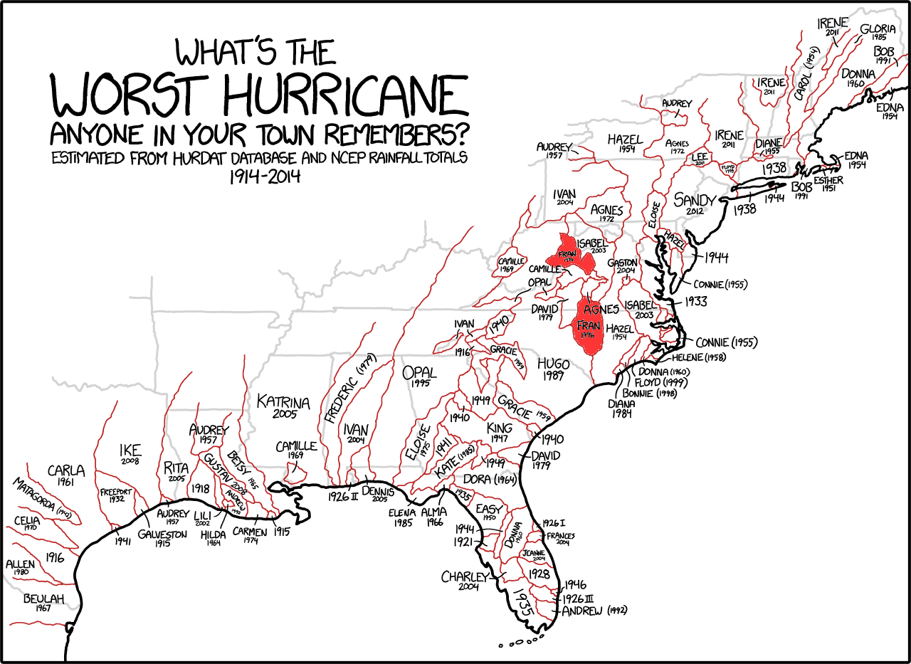
I think it would just cost too much money to do something like that over the vast portion of our country that can be hit by hurricanes.

xkcd.png
 
  • #12
MarkFL said:
I think it would just cost too much money to do something like that over the vast portion of our country that can be hit by hurricanes.

Heh. Suppose Texas gets hit for, say, 1 billion dollars every 10 years.
Then that means that they could spend 1 billion dollars to prevent it from happening in presumably 10 more years.
And after that, they would effectively be saving 1 billion dollars every 10 years.
It may just be beyond the horizon of any political party.

Still, in my country we were also reluctant to spend any significant amount of money on preventive measures,
It took the flood of 1953 with all its casualties that convinced the whole country that we needed to do something.
And then we got the Delta Works, which took many decades to complete.

All in all, something really bad must happen, so bad that all people agree that they never want to see it again, and act on it.

To be fair, the Delta Works are not perfect. They are designed so that the chance of a flood is less than once in 100 years.
And even then, the country is divided into 'walled' regions so that at the worst only a couple of those walled regions might be flooded.
 

FAQ: Hurricane Harvey: Rapid Intensification, Expected to Make Landfall in 24 Hours

1) What is rapid intensification in the context of hurricanes?

Rapid intensification refers to a significant increase in the maximum sustained winds of a tropical cyclone within a 24-hour period. This can occur due to a variety of factors such as warm sea surface temperatures, low wind shear, and a favorable atmospheric environment.

2) How does rapid intensification affect the strength of a hurricane?

Rapid intensification can greatly increase the strength of a hurricane, leading to higher wind speeds and a more dangerous storm. This can also result in a higher storm surge and heavier rainfall, potentially causing more damage and devastation.

3) What is the expected impact of Hurricane Harvey on the affected area?

Based on current projections, Hurricane Harvey is expected to make landfall with strong winds and heavy rainfall, which could cause widespread power outages, flooding, and damage to buildings and infrastructure. The exact impact will depend on the intensity and track of the storm.

4) How can we prepare for the potential impact of Hurricane Harvey?

Residents in the affected area should follow all evacuation orders and take necessary precautions, such as securing loose objects and stocking up on supplies. It is also important to stay informed about updates and warnings from local officials and to have a plan in place for emergencies.

5) Is there a correlation between climate change and the rapid intensification of hurricanes?

While it is difficult to attribute any specific weather event to climate change, there is evidence that warmer sea surface temperatures and other factors associated with climate change may contribute to the rapid intensification of hurricanes. More research is needed to fully understand the relationship between the two.

Back
Top